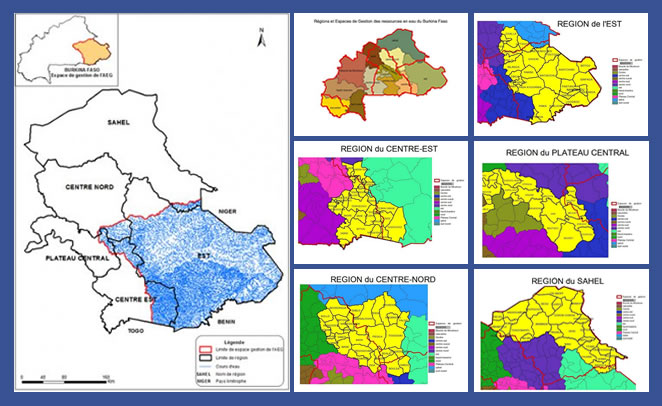
The Gourma water resources management area covers the eastern part of the country. It is a space made up of four (4) sub basins of the national basin of Niger (Sirba, Bonsoaga, Dyamougou and Tapoa-Mékrou) and four (4) sub basins of the national basin of Nakanbé (Kompienga, Pendjari, Singou and Doudodo).
As main features, we can note the following:
Area: 50,238 km2 (i.e. 28,643 km2 of the portion of the Niger national basin and 21,595 km2 of that of the Nakanbé National basin)
Population: 1,737,136 inhabitants
Number of dams: 112
Number of balls: 13
Number of mares: 15
Number of lakes: 03
Number of Local Water Committees (CLE): Three (03) CLE:
- Diapaga in the Tapoa,
- Baskouré in Kouritenga and
- a CLE in the queue for the Sirba sub-basin in Yagha, Komondjari and Gnagna.
Administrative regions covered by the management area: Five (05) Regions:
- the East (entirely the provinces of Gourma, Komandjari, Tapoa, Kompienga and partially the province of Gnagna);
- the Center-East (partially the provinces of Boulgou, Koulpélogho and Kourittenga);
- the Center-North (partially the provinces of Namentenga and Sanmatenga);
- the Central Plateau (partially the Province of Ganzourgou);
- the Sahel (partially the province of Yagha)
Municipalities fully covered: 27
Municipalities partially covered: 23
Fichiers joints
Nombre de fichiers: 1